Download presentation
Presentation is loading. Please wait.

1
Unit 1 Map and Globe Skills

2
What is Geography? Geography is the study of the Earth’s surface and human activities on Earth. The word geography comes from a Greek word that means “description of the Earth.” Scientists who study geography are called geographers.

3
Five Themes of Geography
Location: Geographers begin to study a place by finding where it is, or its location. Regions: Geographers use the theme of regions to group places that have something in common. (population, history, climate, or landforms, etc.) Place: Place includes the human and physical features at a specific location. (hot, hilly, population, language, etc.) Movement: Movement helps explain how people, goods, and ideas get from one place to another. Human-environment Interaction: How people affect their environment, or their natural surroundings, and how their environment affects them.
 Place: Place includes the human and physical features at a specific location. (hot, hilly, population, language, etc.) Movement: Movement helps explain how people, goods, and ideas get from one place to another. Human-environment Interaction: How people affect their environment, or their natural surroundings, and how their environment affects them.")
4
Telling Directions The Cardinal Directions are your 4 main directions. North, East, South, West The Intermediate Directions are the in-between directions. Northeast, Southeast, Southwest, Northwest Most maps have a direction arrow, some do not. If not, assume that the top of the map is North. Some maps will have North pointing in another direction, but the direction arrow or Compass Rose will tell you that.

6
Using Globes A globe is a scale model of Earth. It shows the Earth’s land and water areas and major geographic features (mountains, borders, etc.)
 .")
7
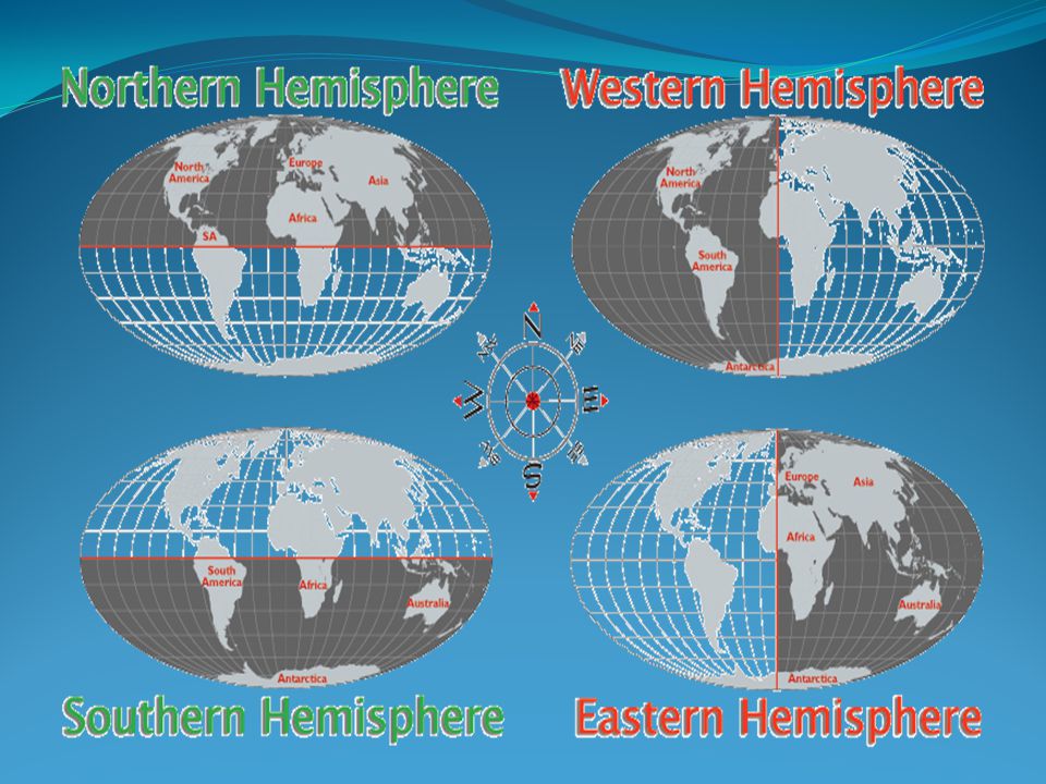
Hemispheres Hemisphere means one half of Earth.
Geographers often refer to 4 hemispheres – Northern, Southern, Eastern, and Western.

9
The Northern Hemisphere is from the equator to the North Pole.
The continents of Asia, Europe, North America, and the northern parts of Africa, and South America are found in the Northern Hemisphere.

10
The Southern Hemisphere is from the equator to the South Pole.
The continents of Australia/Oceania, Antarctica, the majority of South America, and Africa are found in the Southern Hemisphere.

11
The Eastern Hemisphere is from the prime meridian (0˚ longitude) to the international date line (180˚ longitude). The continents of Europe, Asia, Australia, the majority of Africa and Antarctica are found in the Eastern Hemisphere.

12
The Western Hemisphere is from the international date line to the prime meridian.
The continents of North America, South America, and part of Antarctica are found in the Western Hemisphere.

13
Latitude and Longitude
Geographers locate places on the globe by using a global grid. It is made up of lines of latitude and longitude. Geographers measure distance in units called degrees. The symbol for degrees is ˚

14
Latitude Latitude lines are called parallels because they are lines on the globe that run east to west and never meet. They tell distance north and south of the equator. equator - 0° North Pole – 90˚N South Pole – 90˚S

15
Longitude Longitude lines are called meridians because they run north to south on the globe and meet at the poles. They tell distance east and west of the prime meridian. The prime meridian is also known as the Greenwich meridian. Prime Meridian - 0° International date line - 180˚ GPS

16
Understanding Map Projections
A map is a flat drawing of all or part of the Earth. The different ways of drawing maps are called projections. When the round Earth is drawn on a flat surface, some land areas are changed in size and shape and distances are not accurate.

17
Mercator Projection Map
Does not divide the world into sections, but it changes the sizes and shapes especially near the poles.

18
Robinson Projection Map
Very accurate map that is usually used for world maps. Has minor distortions around the poles.

19
Polar Projection Map Shows Earth as if looking down from one of the poles. It is accurate near the center, but inaccurate toward the edges.

20
Map Symbols and Legends
There are many different types of maps. There are political maps, weather maps, road maps, population maps, and many others. All maps have symbols to represent something on Earth. A map’s legend (sometimes called a key) shows the meaning of the symbols. Each map has its own legend to unlock its information. Before using a map, you always need to look at its title, legend, and symbols.
 shows the meaning of the symbols. Each map has its own legend to unlock its information. Before using a map, you always need to look at its title, legend, and symbols.")
21
Political Maps show how people have divided the land.

22
Using Scale What is a scale? How do you use a scale?
You can tell how large or small an area really is by using the map’s scale. The scale on a map is the line that tells how many miles or kilometers on Earth are represented by certain units on the map. One way to make measurements is to copy the scale line on the edge of a piece of paper. Then, to measure distances from one point to another, place your scale on the map where you want.

24
Using a Grid A grid is a pattern of regular sections identified by a system of numbering and lettering. Maps use a grid system and an index (list of places) to help a visitor find the general in which a certain area is found.
 to help a visitor find the general in which a certain area is found.")
26
Reading a Physical Map Physical Maps are concerned with land features that are made by nature. Colors are important because they show the difference in elevation - height above sea level.

27
Highlands are areas like hills, mountains, and plateaus that stand higher than the surrounding areas. Lowlands are areas like valleys and plains that are lower than surrounding areas. Relief is the difference between the highest and lowest points of land in a certain area.

Similar presentations


 ______________________.>")


