Download presentation
Presentation is loading. Please wait.

1
Section 1 The Five Themes of Geography

2
Geography is the study of the Earth’s surface, the connection between places, and the relationships between people and their environment. Geographers look at distances between places, but also oceans, plant life, landforms, and people.

3
Good Geographers always ask two questions: ◦ Where are things located? ◦ Why are they there? To get answers, they use the five themes of Geography. The themes help the geographers to organize information.

4
Location ◦ Geograpers being to study a place by finding where it is, or its location. ◦ There are two types of location. Absolute location: exact location on Earth (EX. 39.95°N 75.17°W - Philadelphia) Determined by position of longitude and latitude lines and measured in degrees. Longitude Lines: (AKA meridians) series of imaginary lines that run north and south through both North and South Poles Latitude Lines: (AKA parallels) series of imaginary lines that circle the Earth and are parallel to the Equator Degrees: a unit of measure used to determine absolute location
 Determined by position of longitude and latitude lines and measured in degrees. Longitude Lines: (AKA meridians) series of imaginary lines that run north and south through both North and South Poles Latitude Lines: (AKA parallels) series of imaginary lines that circle the Earth and are parallel to the Equator Degrees: a unit of measure used to determine absolute location.")
5
◦ Prime Meridian: the longitude line at 0 degrees, runs through Greenwich, England. ◦ Equator: the latitude line that circles the globe at its widest point. Measured at 0 degrees.

6
Location (Cont.) Relative Location: location by describing what is near EX. I live in Newtown Square. It is 13 miles west of Philadelphia. Place ◦ Studying the physical and human features Physical features include climate (hot, cold) and land (hilly). Human features include information like how many people live there, and what kind of work do they do
 and land (hilly). Human features include information like how many people live there, and what kind of work do they do.")
7
Human-Environment Interaction ◦ Studies three things How people affect their environment. EX. People take out parts of the land to build roads and highways. Physical characteristics of their surroundings EX. Turkey receives little rainfall How their environment affects them EX. People must build irrigation systems in order to grow food in Turkey Movement ◦ Movement is important because it helps explain how people, goods, and ideas get from one place to another. Ex. Immigrants bring their traditional food to a new way of life.

8
Regions ◦ Geographers use regions to make comparisons between areas. ◦ Regions have a unifying characteristic such as climate, land, population, or history. Example: The Mid-Atlantic Region ◦ Plain: a flat piece of land

9
Section 2 The Geographer’s Tools

10
Globes ◦ Early maps only showed where people lived and traveled. They often left off information. ◦ As people explored the Earth, maps became more accurate. ◦ The best way to show a map is a globe. Globe: a round model of the Earth Map makers can show the shape of an area according to scale on a globe. Scale: the size or proportion of something on a map as compared to its actual size.

11
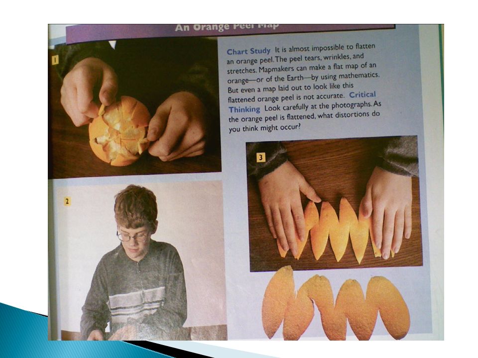
Maps ◦ Maps were invented because of two problems with globes. Tough to transport Can’t make one big enough to show great detail of a small place. ◦ Flat Maps solve those problems, but create their own. Distortion: in maps, a misrepresentation of the original shape and size. An area may look bigger or smaller Example on Next Slide

13
In order to deal with distortion, we have to look at projections. Projection: a representation of the Earth’s rounded surface on a flat piece of paper. 3 of the Best Know Projections ◦ Mercator Projection Correct shapes, but incorrect distances and sizes

14
◦ Peters Projection Correct sizes, incorrect shapes ◦ Robinson Projection Most shapes and sizes correct, most distance accurate

16
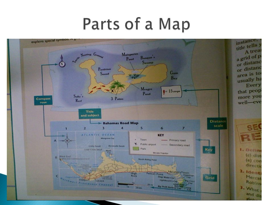
Compass Rose: a map feature that usually shows the four cardinal directions Cardinal Direction: one of the four compass points: north, south, east, and west Intermediate Direction: one of the four secondary compass points: northeast, northwest, southeast, southwest Scale: the size or proportion of something on a map as compared to its actual size. Key: the section of a map that explains the map symbols Title: The name (usually at the top) of a map that identifies what the map is picturing. Grid: Lines drawn on a map to help identify specific places on a map
 of a map that identifies what the map is picturing. Grid: Lines drawn on a map to help identify specific places on a map.")
Similar presentations